
 |
"Jili Strychnine and Eoghan Daly from Ireland travelled through the mystic land of Cherrapunji in Meghalaya in the summer of 2015. Below is their travelogue with some of the stunning photographs of the region the traveller duo took during their stay."
The northeastern states of India are only connected to mainland India by a narrow bottleneck called the Siliguri corridor or chicken’s neck. Most of these so-called ‘seven sister states’ are still relatively unexplored and there is little written about them compared with most Indian states.
Destinations that are relatively uncharted and little explored always lure us like moths to a candle and in the summer of 2015, we travelled to Cherrapunji in Meghalaya state to experience its spectacular waterfalls, explore its lush, forested river valleys and perhaps most importantly of all, to investigate the famous living root bridges that its indigenous people have used for centuries to cross the swollen rivers during the monsoon season.
Location - Sohra (or Cherrapunji)
 |
| Cherrapunji |
The town is situated high atop the Shillong plateau, in the East Khasi hills. This plateau averages about 1,480 m above sea level and lies as much as 1,000 m above the floors of the surrounding valleys. The town itself sits at an altitude of 1,260 m above sea level.
The plains of Bangladesh begin only about 25km south of the town but the nearest border crossing into Bangladesh at Dawki can only be reached by an 85km drive, due to route the road takes.
Getting There
Most travellers will come to Cherrapunji from Shillong. The best thing to do is to take a shared Tata Sumo (MUV) from the sumo stand in Bara Bazaar in Shillong. Ask locals to point you in the right direction. On google maps it’s marked as Lewduh Bus station. There is no timetable for the departures but rather the vehicles leave when full with people.Where To Stay
There isn’t a huge range of accommodation options in Cherrapunji. We stayed in By The Way guesthouse, which was actually excellent, although the guy running it seemed to have a bit of an attitude.We stayed in one of the two much nicer private bungalow rooms at the back of the property for just 500 INR. The rooms in the main backpacker building by the roadside were of a lower standard, but cheaper for solo travellers at about 250 INR per night.
Some background info about Cherrapunji
The term ‘Meghalaya’, given to the Indian state that Cherrapunji is found in, means ‘abode of the clouds’ and the name is very apt for this mountainous state, which is so often shrouded in mist.The town of Cherrapunji has been renamed back to its original name of ‘Sohra’ by the state government. The British pronounced this ‘churra’ and eventually the name Cherrapunji evolved from this, which was actually first used by tourists from other parts of India and it means ‘land of oranges’.
Climate
The town of Cherrapunji is often credited as being the wettest place on Earth but nearby Mawsynram, just 10 miles to the west receives even more rainfall than Cherrapunji according to the Guinness Book of World Records. Mawsynram’s average annual rainfall has been recorded at an incredible 11,871mm.However, Cherrapunji does hold several other rainfall records including the record for the highest annual rainfall total, where in 1861 it received a staggering 26,470mm of rain. It also holds the two-day rainfall record, where on 15 to 16 June 1995, it received an unbelievable 2,493 mm of rain.
Two places in Columbia have also laid claim to the title of ‘wettest place on Earth and one of those is a town called Puerto Lopez, at the foot of the northern Andes Mountains. Unfortunately, Puerto Lopez is said to be missing data for several months in the middle of its 50 years of rainfall recording, meaning that the records can’t be accurately compared to those of other places. Another town that claims the title is Lloro, in northwestern Columbia. However, Lloro’s rainfall measurements were made using outdated gauges so they can’t be relied upon.
Most of the rain that Cherrapunji receives is monsoonal and of the orographic type. Moisture-laden southwesterly winds from the Bay of Bengal blow across the plains of Bangladesh where they’re forced to rise upon meeting the windward side of the Khasi Hills. The vapour-laden air cools and condenses into rain-bearing clouds.
Despite all the rainfall it receives, the town has been ironically experiences water shortages in recent years and residents now have to trek long distances to obtain potable water. They have also had to learn how to harvest and store rainwater and some families now have to purchase water carried in by large trucks. But how on Earth can that be possible? Well, there are a few possible reasons for why this happening.
The first possible reason is climate change. The total volume of rainfall has decreased in recent decades, with Cherrapunji now receiving on average about one third of the annual rainfall it received back in the 1970s.
Also, in recent years, rainfall hasn’t been consistent year-round in Cherrapunji and between the months of November-March, there have been serious drought periods. Rainfall has also generally become more erratic and unpredictable. Another recent trend is localized rainfall, with one locality sometimes receiving plenty and another receiving very little. This was apparently not the case in the past, when Cherrapunji received year-round, consistent and more predictable rainfall.
The second major reason for the problem has to do with the dramatic population increase in Cherrapunji over the last few decades, putting more pressure on the limited water resources, especially during the drier months. In 1971, the population was only about 7,000 but now there are over 100,000 people living in the area.
Local people deny that deforestation or industrialization are to blame, because they say that there never were any large forests around Cherrapunji and what small groves of trees existed they considered sacred and protected them. Also, the only major industry near the town is a cement plant so that can’t be playing a major role.
Another aspect of Cherrapunji’s climate is the cooler weather, due to the relatively high altitude. Average temperatures in January are 11.5°C and still a fairly mild 20.6°C in August with an annual mean of 17.3°C.
Typical landscapes around Cherrapunji
The landscapes of the Shillong plateau are almost completely deforested and could be described as a bleak but lushly green, grassy moorland habitat. Farming is impossible here due to the wet climate, so all the produce is imported from drier areas.The term ‘Scotland of the East’ was originally given by European settlers to the rolling hills around Shillong to the North because the landscapes reminded them of home, but the term is equally valid in its application to the deforested landscapes around Cherrapunji. Despite all the rain, many of the plants here are actually xerophytic (require very little water), to cope with the drought periods in the winter months.
Although the Shillong plateau may be deforested, the valleys that lie below it are quite the opposite, cloaked in lush, green forests and retaining a raw wilderness character. Many rivers carry rainfall towards the edge of the plateau, forming numerous spectacular waterfalls as the water flows over the precipice and tumbles down into the deeply cut valleys below, before being carried away to the plains of Bangladesh.
The rains also carve fascinating caves out of the limestone rocks in the area and Meghalaya state is known to have over 1,500 of them, of which only about 980 have been explored and many of these only partially. Of the 10 longest caves in India, 9 are found in Meghalaya and this state has the longest cave in all of India, known as Krem Liat Prah. With over 31 kilometres of explored length, Krem Liat Prah is also one of the longest caves in the entire world.
The biggest threat currently facing these incredible caves is limestone mining for the cement industry and conserving them is very important, as many provide habitat for many rare species of bats and other poorly understood creatures.
People
 |
| Khasi Girls of Meghalaya |
In Khasi society, the youngest daughter always inherits the property or if the couple has no daughter, they’ll adopt one and she'll then inherit the property. The youngest daughter also plays a pivotal role in educating and looking after her siblings, as well as her parents in old age.
Khasi children take the mother’s surname and the men once married have to live in the home of their mother-in-law and get bossed around by her (and their wife) all day. With no property, little security and no role in the family business, many Khasi men feel pretty powerless and useless. Many thus end up as alcoholics and die at a young age.
The reason for this system may have to do with the history of the Khasi people, where men were always away from the village for long periods of time, at war with neighboring tribes. The womenfolk thus developed a central role in raising the family.
However, Khasi women don't technically rule the society; in other words it’s not a matriarchal society. Their political power is limited. In the past for example, it was the son of the King’s youngest sister that would inherit the throne and in today’s world, women are minimally represented in village councils or panchayats.
Christianity has a strong influence over the Khasis, with about 85% identifying as Christians. The religion has played a role in the relatively high literacy rates of the people of Cherrapunji (74% vs the national average of 59.5%) but it has also somewhat diluted their indigenous culture.
 |
| A cemetery in Cherrapunji |
There are also many small Christian cemeteries dotted around the landscape, normally found atop small knolls, where you’ll find gravesites and stone Christian crosses that mark them.
Other notable monuments that are found throughout the length and breadth of the Khasi and Jaintia hills are the Khasi monoliths; horizontal stones on supports and vertical standing stones (menhirs) that have been erected by the Khasi people in honour of dead clan members or of those who have died heroically in battle. The vertical standing stones represent men, while the horizontal ones represent womenfolk.
One such cluster of monoliths can be found by the roadside on the way to Mawsmai cave. The largest and most impressive collection of these monoliths however is in Nartiang, which is found in the Jaintia hills, about 100km to the northeast.
To be able to work outdoors in the rainy climate of Cherrapunji, the people wear a somewhat comical-looking type of umbrella called a knup, made by sandwiching two layers of palm leaves between two loosely woven bamboo lattices.
Perhaps the most fascinating features of Khasi culture are its phenomenal living root bridges, which allow the people to safely traverse swollen mountain rivers in the monsoon season. Many Khasi people occupy remote villages that are hidden away inside the wild forests that cloak the lower valleys beneath the main plateau, and it is in here that you can find several of the famous living root bridges, which we’ll show you in more detail shortly.
The Layout
The accommodation in Cherrapunji is not all concentrated in one place, rather the various establishments are scattered haphazardly for several kilometres south of the town. There are a few decent local restaurants located at the T-junction just a few hundred metres to the south of the ‘By The Way’ guesthouse.Waterfalls, waterfall viewpoints and caves are found both North and South of Cherrapunji town; there is one other cave (Arwah cave) just off the map to the north that we have not included on this map.
The living root bridges are found around the small Khasi village of Nongriat, which can only be accessed by descending down into the valley from Tyrna on foot, or by a much more longer and more challenging hike from Nokhalikai Falls.
The waterfalls here in Cherrapunji are some of the most spectacular in the world and they include India’s highest plunge waterfall. We recommend you check out these 4 waterfalls: Nohkalikai Falls (highest in India), Nohsngithiang waterfall (seven sisters falls), Kynrem Falls and the remote Rainbow waterfall, which is impossibly beautiful and surreal.
Nohkalikai Falls
 |
| Nohkalikai Falls |
Getting there:
To reach the viewpoint for Nohkalikai falls you have to get onto the Nohkalikai road, by heading directly west from Cherrapunji town. It’s a bit of a mess of roads until you finally reach the longer uninterrupted road headed straight for the viewpoint. Ask locals to point you in the right direction if you get lost.
The waterfall can also be reached from the village Nongriat in the valley below, where the double decker root bridge is found. This is how we reached it. If you can imagine stumbling upon a waterfall like this after a challenging 1,000m of vertical ascent from the valley below…. that’s exactly how it was.
Additional Info:
Being the tallest plunge waterfall in India, this is a pretty popular spot with domestic Indian tourists so it’s unlikely that you’ll have the viewpoint to yourself. There are a few snack stalls and souvenir shops around, selling various tribal handicrafts, wild jungle honey and other interesting products. We caved and bought a bottle of honey:
If you’re curious about the origin of the name, it means ‘the jump of Ka Likai’ in the Khasi language and there’s a grisly legend associated with the waterfall.
As the story goes, a woman called Ka Likai lived in a small village at the top of the waterfall with her beloved daughter and husband. One day her husband tragically died, forcing her to remarry.
While married to her new husband Ka Likai would work long days as a porter to earn money to support her family but whenever she returned home after work, she would give all her attention to her daughter and that made her new husband begin to grow jealous. This continued for a period of time until he finally cracked one day and killed the daughter, cooking her flesh but discarding her head and bones.
When the mother returned home that day, she noticed her daughter was missing and wanted to look for her. However, because she was tired and hungry, she sat down and ate the meal that her husband had prepared for her.
After the meal she went to prepare paan (Betel leaf and areca nut digestive aid) and that was when she found a severed finger of her daughter.
Realizing what had happened, the woman went mad with grief and ran outside the house while swinging a hatchet in her hand, eventually throwing herself over the edge of the waterfall nearby. Hence it’s now named after her.
Nohsngithiang Waterfall
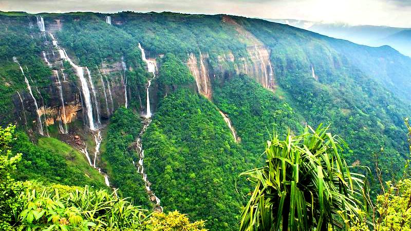 |
| Nohsngithiang Falls |
Getting there:
It’s actually possible to reach the top of this waterfall if you head to the Eco Park, located about 5 kms to the south of Cherrapunji town.
There are also several excellent viewpoints of the waterfall for which you just keep heading south past the Eco Park along the main road, until views of the waterfall start to appear on the left hand side. There are several good vantage points along here but the best one is at the 7 sisters falls view inn, located just off the main road, about 4.5km south of the town.
At the Eco Park, you can take a wander along the edge of the plateau and peer out over the edge at the falling water at a point where a river flows over the edge. This southern region of the park is the originating point of the Nohsngithiang Falls.
From up here, there are also some spectacular views of the valleys below and beyond to the Sylhet plains of Bangladesh when visibility is good.
The park is also famous for its vast variety of indigenous orchids, which were donated by the Shillong Agri-Horticultural society and are kept in the Green House.
It’s a very popular place with Indian tourists and they come in swarms because it has facilities that take the difficulty out of experiencing Cherrapunji. There are concrete pathways through the grassy habitat and also an arching concrete bridge spanning the main river that flows off the plateau.
Kynrem Falls
 |
| Kynrem Falls |
Getting there:
You just have to follow the main route 5 heading south from Cherrapunji. It heads south for about the first 12km and then starts to head west and then north for the last 4.5 km towards the falls.
Additional Info:
This is the 7th highest waterfall in India and is situated inside the Thangkharang park, another popular tourist spot in the area that’s famous for its rare orchids and plants.
Other than looking up at the waterfall from the road bridge, there are a few viewpoints of this waterfall from afar, which allow you to clearly see its three different levels. One of these is found a little ahead of the falls and there is also a view of it from the Thangkharang park, allegedly. We can’t give you more information on this because we didn’t visit this one, due to the difficulty in getting to it.
The Caves
As we mentioned earlier, Meghalaya state has over 1,500 caves in total, but the two most accessible aves in the area around Cherrapunji are Mawsmai Cave, which is a show cave exclusively for tourists and the less visited but more interesting Arwah Cave, which only recently came into the limelight after being discovered by local men.Another cave in the area is Mawmluh Cave, which is a very long, wild cave that’s much more challenging to navigate, meaning that tackling this will be somewhat of a mini-expedition.
Most of these caves support several species of bats (including some rare species) and also a variety of insects (centipedes, spiders, millipedes, beetles etc.) and crustaceans (copepods, freshwater crabs, crayfish etc.). Some caves even support the curious blind and albinic cave fish (Nemacheilus evazardi), an only recently discovered species, but they are only found in a few caves in Meghalaya.
Mawsmai Cave
 |
| Mawsmai Cave |
Getting there:
Mawsmai cave is easy to reach. Just follow the main road south from the town and take the right turn after about 5km. Take another right turn about 300m down this road and you should wind up at the cave.
Additional Info:
Since this is a very popular site with tourists, there are many shops and souvenir stalls outside, most of them selling a lot of useless junk.
There’s a small entrance fee of about 60 rupees here, as well as additional fees for cameras. As far as we can recall, the path from the cave exit meets the main path before you reach the ticket booth, so you can try avoiding the fees by heading down this path, entering through the cave exit and navigating the cave in the reverse direction. However, you might find it difficult to negotiate your way past the one-way flow of Indian tourists at the bottleneck sections of the cave.
Not knowing about the path from the cave exit, we went ahead and bought tickets and did the cave in the normal direction. A path through the forest leads you to the cave entrance but just a short distance in we encountered a few bottlenecks, where the cave was completely blocked by slow-moving Indian tourists, making for long, frustrating delays.
However, once we got past the narrow bottlenecks near the beginning, we were able to proceed through the cave more swiftly. The cave is illuminated by electric lighting and wooden planks have been laid down to help people navigate the cave.
It was waterlogged in many places but never much more than ankle deep. A lot of water was also dripping from the cave ceiling and from the stalactites in many sections, so make sure you don’t mind getting a little wet.
There are a few interesting features like stalactites, stagmites, pillars etc. along the journey througoh the ave but nothing particularly mind-blowing.
Overall we’d have to say that we weren’t overly impressed with this cave, if we're to compare it to other caves we’ve explored in Southeast Asia. You eventually emerge from the cave through an opening at the far end and a path leads you from here back to the main entrance.
Arwah Cave
This cave, also known as Lumshynna or Lawshynna cave, lies within the slope of U Lum Lawshynna hill and extends for 3 kilometres, although only the first 300m or so is open to tourists. It’s located about 3.7km north of Sohra town. We didn't visit this cave but the reports that we've read of it sound quite promising.Getting there:
To get to this cave, just head out the main road towards Shillong from Sohra town. Only about 500m out the road, there’s a right turn down a dirt road. Take this right turn and follow the road north all the way to a parking area. From the parking area it’s about a 500m walk up a hill to the cave entrance.
Additional Info:
This cave does get a few of visitors, although not as many as Mawsmai Cave. At the beginning, it’s a much wider and more spacious cave than Mawsmai and with a higher ceiling, making it altogether less claustrophobic. However, it does get narrower and tighter as you proceed deeper into the cave. A stream runs through the cave so you’ll feel like you’re walking upstream along the river.
The cave is notable for its fossils, which are abundant within the cave and found imprinted all over the walls and ceiling of the cave. The fossils were left by gastropods and other marine creatures, indicating that this area was once underneath the ocean!
Mawmluh Cave
This is said to be the 4th longest cave in India and is over 4.5km in length with 5 different river passages. The cave entrance is found at the base of the western flank of Lum Lawbah (Lawbah hill), near the Mawmluh-Cherra Cements factory, which is located about 5km to the southwest of Cherrapunji.We didn’t even know about the existence of this cave when we visited Cherrapunji. It’s a completely wild cave, that hasn’t yet been tamed for tourist visitors and exploring it will involve more of a mini-expedition.
Getting there:
You can get to this cave by first following the Sohra-Laitkynsew Road out of town until you reach the cement factory.
A river flows out of the cave and one of the cave entrances can be reached by following the river upstream until it disappears underground. However, reports suggest that this entrance requires wading through water during the wet season and wading through dangerous dry quicksand during the dry season.
There is a better entrance to the cave system higher up on the hillside, reached by hiking uphill through long grasses and vegetation. It may be difficult to find though, so it may be a good idea to have a guide if it’s your first time.
Additional Info:
It seems that most people explore this cave with a guide or within a small group where at least one person knows what they’re doing. It’s quite a serious undertaking.
Reports suggest that the cave is quite complex with many winding passageways and that it’d be quite easy to get lost if you weren’t paying attention to the landmarks.
There are sections that require wading in cold deep water (more than thigh-deep) and during the monsoon season the cave might be completely flooded with water and impossible to navigate.
There are also sections that require climbing up and descending down steep cliff faces, although none are particularly high. Ropes may be needed for some sections.
Within the cave, there’s the chance to witness beautiful limestone features, including stalactites, stalagmites, pillars and others. Bats are definitely living in the cave and blind cave fish may also be present.
The Root Bridges
 |
| The Living Root Bridges |
East of Cherrapunji for example, there are living root bridges to be found in the Khatarshnong region, in and around several villages including Nongpriang, Sohkynduh, Rymmai, Mawshuit and Kongthong and most likely several others.
In the East Khasi hills where Cherrapunji lies, root bridges can be found in and around the villages of Tynrong, Mynteng, Nongriat, Nongthymmai, Laitkynsew and others.
Mawlynnong (the cleanest village in Asia) has a very famous one that attracts hordes of tourists each year and what’s assumed to be the longest one in existence is found near the small Khasi town of Pynursla; this one is allegedly over 50 metres in length! However, nobody can confirm with certainty that this is actually the longest since a comprehensive investigation of the root bridges has not yet been carried out.
For those visiting Cherrapunji, the most accessible root bridges are those in and around the small Khasi villages of Nongriat and Nongthymmai, which are very near each other. We counted at least 5 living root bridges when we explored these two villages and their surrounding areas.
to read Eoghan and Jili's journey to Nongriat.
Final thoughts
Cherrapunji is a unique and incredible place. We have visited countless destinations over the past few years but Cherrapunji has to be one of our all-time favourites. The sheer majesty and untainted wildness of its landscapes and its breathtaking natural wonders and cultural treasures will leave you hungry for more. We were truly sad to leave Cherrapunji but we would surely return in a heartbeat to explore more of it.About the authors
 Eoghan Daly and Jili Strychnine hail from Ireland and India respectively. They are two ardent shoestring budget adventure travellers and have been travelling throughout Asia continuously for the past few years. Do visit their website twobirdsbreakingfree.com for their stories, philosophy and mission.